Recently, road enthusiasts all over the world have submitted their good green road practices, which all share a common goal: to transform our roads into sustainable, climate-resilient, and eco-positive ‘Green Roads’. The open call was launched by MetaMeta Research and the International Road Federation, who have been engaged by the Asian Development Bank to develop a Green Roads Toolkit, which will be used for planning and preparing future road project investments. If you’re curious to learn more about this open call and the innovative Green Roads Toolkit, you can find additional details here. Originating from every corner of the world, the applications we received covered a diverse array of green road themes. Each application was assessed based on six key criteria: impact, applicability, cost efficiency, appropriateness for the Asian context, innovativeness, and the overall quality of the submission.
The applications highlighted important measures to support the concept and goals of Green Roads such as community organization in the Guaviare region of Colombia, pedestrian safety measures implemented in Mexico, cold pavement recycling used in the Caribbean, and tree planting efforts in Uganda and more! . Your contributions have left an indelible mark on the road to a greener, more sustainable future.
It is important to note that every single application has played a vital role in shaping the Green Roads Toolkit. However, with great pleasure we are happy to announce the following individuals as our challenge winners: Michael Maluki from Kenya, Pedro Moreira from Portugal, and Pawan Karki from the ADB have emerged victorious!
In recognition of their remarkable achievements, each winner will receive a personally signed copy of “Crossings: How Road Ecology Is Shaping the Future of Our Planet” by the esteemed environmental author, Ben Goldfarb. This thought-provoking book takes readers on a journey to explore the global ecological impacts of roads and, most importantly, offers invaluable insights on how to mitigate these impacts.
We would like to congratulate the winners and express our gratitude to all participants for their dedication to the cause.
Inclusive growth with green roads in Kenya
Several good green road practices are applied in Makueni Country in Kenya, an arid area. Better coupling water management and road infrastructure is very promising in this area, as it allows for an improved utilization of the scarce water. To make those interventions a reality, local communities are involved in making cut-off and mitre drains and rehabilitating gullies to achieve the desired outcome of climate resilience and improved community livelihoods. Positive and frequent road surface drainage measures are fundamental for achieving climate resilient roads, and use of the drainage water is both practical and important. Also, in contracted projects, the contractors are instructed to engage the local communities around the specific projects to manually implement the programs at a fee, boosting the local economy. The government of Makueni County is the driving force behind the successful mainstreaming of green road practices, facilitated by Michael Maluki (Superintendent Roads Engineer, Government of Makueni County-Kenya, Department of Infrastructure, Transport, Public Works, Housing and Energy). The upscale is further boosted by communities now willing to take the practices by themselves, having seen the positive impact on their livelihoods and creating a resilient infrastructural development and climate resilience.
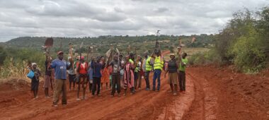
Figure 1 Community involvement in green road activities and interventions in Kenya
Using a digital twin for sustainable and climate-resilient infrastructure in Uzbekistan
Moving from very social practices in Kenya, we arrive at a very technical and promising application: using digital twins for sustainable and climate-resilient infrastructure. For a specific new road in Uzbekistan, the possible impacts have been mapped with a digital twin, allowing one to come up with an alternative, and in this case, with low-carbon, low-cost, sustainable materials for road construction. With a multiple-scenario digital analysis, it facilitates the making of informed and data-driven decisions at an early stage, while improving the design performance in the real local context of a new road project. For the specific application in Uzbekistan, ADB CWRD, together with the ITD sandbox program, completed a joint initiative in 2021 (digital twin for sustainable linear infrastructures) for the A380 highway upgrade in Uzbekistan. AI and the digital twin have been employed here in conducting due diligence to design the road upgrade in a sustainable manner (reduced environmental footprint, cost-efficient design, resilient to climate change, and reduction in fatalities by 10%).
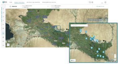
Figure 2 Project Location of the A380 Highway (section 673–698 km) Upgrade in Uzbekistan
Intervening at the right place: determination of animal-vehicle collision hotspots in Portugal
Animal Vehicle Collisions (AVC’s) are identified as a significant cause of mortality in wild animal populations in most regions of the world. This topic has become an important issue in road ecology because of the increasing human and economic consequences and the pervasive effect on many species. Due to the increase of traffic intensity and the gradual growth of the road network, which bisects otherwise continuous natural areas, the topics of habitat fragmentation and wildlife collisions are becoming increasingly important. Identifying AVC hotspots is crucial to implementing specific mitigations measures well adapted to a particular species and to the singularities of each road segment. These custom-made measures increase the effectiveness of each action and focus the efforts on maximizing the results, that is, the reduction of animal mortality. What has been done for a road network in Portugal is to develop a wide study in real time that allows for identifying the AVC hotspots specific to a species or taxonomic group. This study resulted in GIS maps that are an excellent input for decision-making who may be considering the construction of wildlife overpasses or underpasses. This practice has been implemented in the Ascendi network, encompassing over 600km from north to centre of south Portugal. This methodology is, however, not restricted to a specific location and can be widely applied to every road network, regardless of the type of animal species, habitats, or traffic volume.
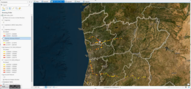
Figure 3 Determination of animal vehicle collision hotspots in a GIS environment
Last modified: November 23, 2023