The basic idea of “roads for water” is to make roads instruments of beneficial water management and resilience. Roads make a major imprint on hydrology. They block and guide water, concentrate runoff, interfere with subsurface flows, and change flooding patterns. Ibisch et al. (2016) describe the fragmentation of landscapes that has come with road development. They calculate that, at present, 20 percent of the global land surface is within one kilometer (km) of a road. These are also the areas where most people live and where economic activities are concentrated. If there is an opportunity to contribute to greater water security, it is this: ensuring that roads contribute to water management.
The impact of roads on landscapes and surface hydrology is often negative. Roads cause erosion and local flooding and trigger sedimentation. Road bodies are a main reason for drainage congestion and waterlogging. Roads disturb wetland hydrology, affecting fish movement. In some desert regions, roads trigger sand dune movement. Transect surveys undertaken along roads in upland Ethiopia and Uganda show that in every 10 km of roads there may be 8 to 25 flash points, such as local erosion, flooding, sedimentation, or waterlogging. According to research in Tigray, Ethiopia, road runoff affected 70 percent of roadside farmers, but only 20 percent were making productive use of that runoff (Teweldebrihan 2014). Data from two coastal polders in Bangladesh show that 60 percent of farmers are affected by impeded drainage due to roads.
The impact of roads on the surrounding landscape is not going to diminish; it will increase. Many more roads and railways will be constructed in the coming decades. Dulac (2013) estimates that 25 million km of paved road-lanes and 335,000 km of rail-track will be added from 2010 to 2050: a 60 percent increase. The estimated costs of this new infrastructure in highways and railroads over four decades are US$45 trillion. Unpaved road networks, the majority of roads in most countries, will also continue to expand, adding to this total. Another projection is from ADB (2017). The investment required in infrastructure in Asia is USD 1.3 -1.7 Tr / year with the cost of climate proofing transport infrastructure USD 37 Bn. Most expert estimates are close to this bandwidth. In preparation for the Addis Ababa Summit on Finance, the High-Level Advisory Group on Sustainable Transport estimated that annual investments in transport amount to US$1-2 trillion, of which 40 percent is in developing countries.
However, there is another beneficial connection between roads and water management. Water is also considered the prime enemy of road infrastructure and the single greatest factor in road damage. A commonly used estimate is that for unpaved roads, the damage caused by water is around 80 percent (Chinowsky & Arndt, 2012) and for paved roads the proportion is 30 percent. Therefore, there is a strong case for road-asset management to better manage water around roads and to see roads as an integral part of the watershed and landscape in which they are situated. Such an integrated approach will preserve road infrastructure and reduce the maintenance burden, contributing to greater infrastructure productivity. Dobbs et al. (2013) advocate that there should be more upfront planning in infrastructure development. With other measures, this can contribute to a 40 percent savings in infrastructure needs.
Opportunities
These guidelines are targeted at road planners, infrastructure investors, private road developers – be it at the World Bank, the partner countries or elsewhere. They are also targeted at other communities of practice: those that work in flood prevention, land scape restoration, agricultural development, climate resilience, disaster risk reduction and environment in general.
This Guideline describes how the negative impact of roads on the surrounding landscape can be turned around and how roads can become instruments of beneficial water management. Roads in terms of the World Bank (2017) Environmental and Social Framework are often categorized as ‘high risk’ or ‘substantial risk’. Yet precisely because of the close connection among roads, surface, and subsurface hydrology, roads provide an enormous opportunity to contribute to better water management and climate resilience. This will create the triple benefit of less road damage, less land degradation, and more beneficial use of water..
Many measures can be taken to manage water with roads. These are the main opportunities:
- In arid areas, roads can be used to harvest water (van Steenbergen et al. 2018). The water intercepted by road bodies can be guided to recharge areas or surface storages or applied directly on the land. With the enormous lengths of roads being built, roads in many semiarid areas present the main opportunity for water harvesting and water buffer management (Sambalino 2015).
- Roads can also be used to manage water catchments by controlling the speed of runoff, compartmentalizing and mitigating flood runoff, and influencing the sedimentation process in the catchments. The choices of where to place a road in a catchment and additional measures to include have a major impact on how a catchment is managed.
- High-altitude catchments present special challenges that require a more intensive integrated landscape approach than is common today.
- In floodplains and coastal areas, roads play a role in flood protection. Roads often double as embankments and provide evacuation routes and flood shelters. In low-lying wetland areas and floodplains, roads and bridges affect the shallow groundwater tables and have enormous consequences for land productivity. The way in which a road is built, and, for instance, the height of bridge sills and culverts will have considerable influence on the quality of the wetland on either side of the road.
- Roads can improve pastoralist areas for instance by combining the concentrated run-off from roads with planting native grass species. Similarly, the road run-off can be used to rekindle the roots of useful tree species under farmer managed natural re-vegetation programs in very dry areas. Under such programs dormant tree shoots that come up after a sporadic watering event are systematically pruned and local tree stands in such harsh environments.
- Roads can also be used to control sand dune movement or at least not aggravate it. The first consideration is to avoid constructing the road in the prevailing wind direction, because this will create a wind-tunnel effect that triggers sand motion. The second consideration concerns roadside vegetation that will stabilize newly opened areas.
- Roads may serve to protect wildlife areas. Wildlife movement is very much guided by the availability of water. The collection of runoff in designated storage within wildlife parks can support wildlife management and regreen designated areas within the wild life parks. It can also be used to improve buffer areas just outside wildlife areas so as to prevent encroachment by livestock keepers or farmers.
All such measures should be part of the Environmental and Social Commitment Plans of road investments, not just to address risks, but to make use of opportunities. Even much further, Green Road investments – either in new roads, retrofitting existing roads or systematically exploiting the scope for road related water management – should be developed as major ventures for climate resilience, addressing the challenges of scale and additionality.
Promoting resilience: three levels
This Guideline explains the positive contribution that roads can make to climate resilience. There is now considerable debate on the effect of climate change on road infrastructure and the need to reduce road infrastructure’s risk of exposure to more intensive runoff and more frequent flood peaks, in addition to dealing with rising temperatures. The concern for resilient roads often translates into a protective approach under which road infrastructure is safeguarded at any cost from more inclement weather. [See Transportation Research Board (2008) Farrag-Thibault (2014), NDF (2014), Hebson (2015) or Cervigni et al. (2016)]. Ebinger et al. (2015) rightly has made the point that the loss caused by disrupted transport infrastructure can be enormous and sheltering roads from climate impact is extremely important. Under a Protective resilience approach, road infrastructure specifications are adjusted to accommodate temperature rise and to be better able to withstand expected larger flood peaks or as the climate may be deal with deteriorating permafrost condition, more extreme freeze and thaw cycles or extreme colds.
Therefore, the key concern is the road itself. The downside of this protective Basic Resilience approach is that the road itself may be sheltered from the impact of higher flood peaks with better cross drainage. This is essential to keeping the economy running. However, the landscape around the roads will suffer even more from the effects of climate change, because all extreme weather events are immediately passed on to the area surrounding the road, causing larger floods, more inundation, and heavier erosion. The second downside is that no use is made of the road’s potential to contribute to water management and greater resilience in the area of which it is a part.
Instead, we argue that by integrating water management in road development and design, a “plus” strategy to road resilience can be taken. The environment around the road is managed, and the road is made part of the landscape, even as a beneficial instrument for water management. In most cases, this roads-for-water approach will equally reduce road damage and bring down maintenance and sometimes even construction costs.
The Resilience Plus approach to climate resilience is a preferable addition to the protective Basic Resilience approach of adjusting road design specifications. By building roads that can serve several purposes beyond transport, and by making these functions part of the design and development of roads, it is possible to create roads that: (a) reduce the often substantial collateral damage of uncontrolled road water on the landscape around it; (b) are likely to have lower maintenance costs and downtime and are generally better able to withstand weather effects, including those that are caused by climate change; and (c) generate substantial benefits in terms of water harvested with the roads and other beneficial water management functions. In other words, rather than being a source of landscape degradation, roads can become instruments for climate change resilience.
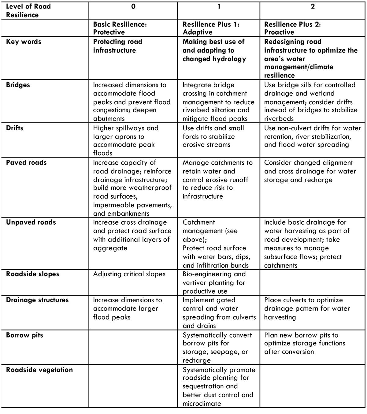
There are two levels in this “plus” approach. The first level is Adaptive: it makes use of the road infrastructure as it is and adds a number of measures to improve water management.. The second plus level is Pro-active. It goes back to the drawing board and, from the onset, proactively plans the roads that serve to optimally contribute, within economic parameters, to better land and water management, besides offering better communication. These different approaches—Protective (basic), Adaptive (plus 1), and Pro-active (plus 2)—are largely complementary. Measures aimed at basic Protective road resilience can be incorporated and complemented by approaches at the Adaptive and Pro-active levels. Table 1.1 describes the road-resilience measures at these three increasing levels of road resilience for different geographies. Table 1.2 presents the same but for different elements of roads.
Table 1.1. Three levels of road resilience in different geographies
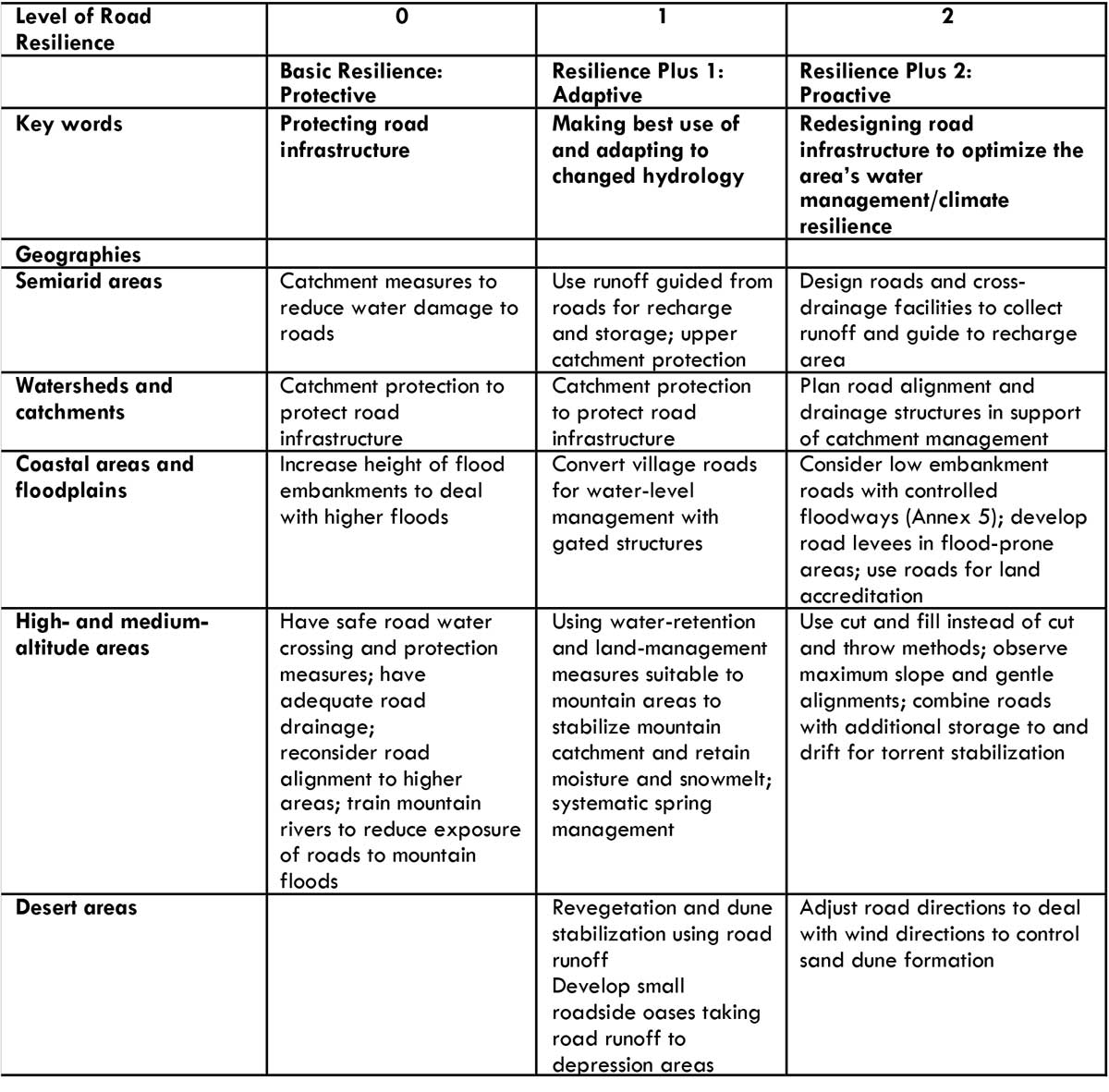
Table 1.2. Three levels of road resilience for different road elements
Costs and benefits
With “Green Roads for Water,” we argue for a new approach where beneficial road water management is an integral part of the design, development, and maintenance of roads – promoting resilience but also tangible economic benefits. The economic case is based on a number of co-benefits:
- Management of water with road infrastructure presents a triple win: reduced road maintenance costs; reduced landscape degradation; and productive and consumptive use of water harvested with the roads.
- The approach has minimal costs compared to the overall outlays for road investment or road repair/maintenance (see chapter 15). The additional costs related to design modifications, including road water management from the start, is estimated at a maximum of 5 percent of original investments planned for the road. This may be funded from climate funding top-ups for road infrastructure programs.
- The approach is the best option for climate resilient infrastructure. The costs associated with building roads that harvest water and manage floods provide a cheaper alternative to building road bodies with heavy new design specifications to deal with the expected impact of rain storms and other effects of climate change.
Conventional approaches to resilient roads may preserve the road in times of heavier weather but will do far more damage to the surrounding landscape and incur more economic costs. Larger cross drainage and higher and stronger road embankments will mean more uncontrolled flooding, erosion, sedimentation, and water logging triggered by road infrastructure. Whereas in the Adaptive Resilience approach the environment around the road is managed and the road is made part of the landscape, even using roads as a beneficial instrument for water management, in the conventional Basic Resilience approach road infrastructure design specifications are adjusted to make the road better able to withstand adverse weather effects. To deal with more intense rainfalls, culverts are adapted so that they can handle larger volumes of water. The cost of this conventional approach to road resilience is high: from US$31,000 to US$45,000 per km. In the case of unpaved roads, the costs may be prohibitive.
The cumulative annual dividend of the roads for water approach to resilience, as implemented in Ethiopia, is US$16,879 per km. This compares favourably with the direct investments of US$1,800 per km. These investments are largely in earthwork measures implemented under the Mass Mobilization Watershed Campaign. If one were to include the cost of organizing and developing this program, another US$1,800 could be added. Even then, a fourfold return on investment is achieved in the first year. It comes as no surprise that the program has spread quickly in the different regions of Ethiopia. The measures implemented in Ethiopia comprise simple earthworks-based interventions—floodwater spreaders, roadside water ponds, and infiltration trenches, many of which are explained in Chapter 2—with no engineering required. It is a minimum but cost-effective package. For the calculations, monitoring data from the Ethiopia’s ‘Roads for Water’ program and from other sources has been used. We work out the case in more detail in Chapter 15.
Moreover, research in Kitui, Kenya, shows an average increase in a farmer’s income of US$ 1,000, after one cropping season, whereas the average cost of road water infrastructure was US$ 400. This means that a net benefit of US$600 was achieved after just one cropping season. Hydrological modelling on Polder 26 in coastal Bangladesh shows that improved drainage will decrease waterlogging significantly: areas with high water levels (F1:31-90cm) decrease by 287 percent, increasing less inundated areas (F0:0-30cm) by 157 percent and making more land available for agriculture. Moreover, the duration of the drainage would be lessened by 10 days in low lying areas. When water logging is removed completely, farmers can do multi-cropping (70 percent Boro/Aman rice, vegetables, watermelon, and sesame), increasing agricultural productivity by 300 percent. Thus, if Boro rice could be cultivated (1680ha) without water logging, the net benefit will be 270 mill Taka (US$ 3.1 Mill).
Organization of the Guidelines
The Guidelines focus on the adaptive and proactive (‘plus’) approaches to road resilience (section 1.3), exploring how to make roads instruments of water management and climate resilience. The Guidelines are a complement to the normative work on resilience rating, the transformation of ‘brown’ infrastructure to ‘green’ infrastructure and the optimization of co-benefits. The Guidelines have drawn from work in the professional communities in road development, water management, climate resilience, disaster risk reduction, and agricultural development. The Guidelines aim to be as practical as possible. Building on Table 1.1, the scope of the intervention, the opportunities offered, and specific good practices are discussed in all chapters.
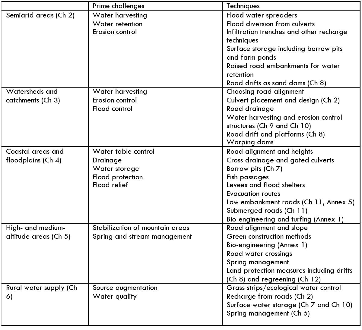
The Guidelines follow a matrix structure. They first discuss the approach for a number of different geographies: water-short semiarid areas (Chapter 2); water catchments (Chapter 3); low-lying flood-prone areas (Chapter 4); and middle- and high-altitude zones (Chapter 5). Each area has its own opportunities, sets of appropriate measures, and dos and don’ts. Chapter 6 looks at the relation between roads for water and rural water supply. The second section (Chapters 7 to 12) concentrate on some of the most important techniques, providing, to the extent possible, practical details of the available options. The following interventions are discussed: the conversion of borrow pits; the use of road drifts; the development of local storage; the development of roads in low-lying floodplains; harvesting water; and promoting groundwater recharge with unpaved roads and roadside tree planting. Specific details of a technical nature are covered in the annexes. Table 1.3 is a ready reckoner table showing the prime challenges and the appropriate techniques for the different geographies. The last chapters of the Guidelines discuss how to make Green Roads for Water work: what governance arrangements are conducive to integrated road development and management with climate resilience and water management (Chapter 13) and how to effectively engage with roadside communities. The last chapter (Chapter 15) caps the Guidelines with a detailed economic assessment of the main early example of the approach, the roads for water program in Ethiopia as well as a preview into of some other programs.
Table 1.3: Matrix of geographies, challenges, and techniques
The Guidelines are prepared on the basis of considerable empirical knowledge. Complemented by information from secondary sources, they combine experience from different countries, in particular Bangladesh, Bolivia, China, Ethiopia, Kenya, Mozambique, Nepal, Portugal, Sudan, Tajikistan, Uganda, Yemen, and Zambia. In all these countries, a first step has been taken by promoting beneficial road-water management. The authors hope that this development will continue, that more countries will become involved, and that the Guidelines will contribute to this effort.