The location of a road in a catchment has a major impact on the volume of water that can be captured by the road bodies and the sediment that is generated and intercepted. The location of roads in a catchment is guided by a number of important general considerations, as shown in Table 3.1.
Table 3.1. Socioeconomic, morphological, and environmental criteria
for the location of (new) roads
| Socioeconomic: | |
| Short connection | Preference for shortest connection between centers of activity |
| Property | Location away from valuable property or land use that would be negatively affected |
| Morphological: | |
| River crossings | When following a river course: minimize the number of crossings |
| Cuts and fills | In mountain areas: avoid high fills and deep cuts |
| Hairpin bend | In mountain areas: avoid or at least minimize the number of hairpin bends |
| Mid-slope areas | In mountain areas: for road development, avoid long, steep areas |
| Rise and fall | In general: avoid needless rise and fall of the road; preference for gradual climbing and descending of the road bodies |
| Sunny areas | Preference for sunny areas to reduce the potential negative effect of damage by soil moisture |
| Ridges | On smooth hill ridges, it may be preferable not to change runoff patterns, shifts, and high costs due to cut/fill |
| Foot of the slope | Expect high runoff pulses, especially in semiarid environments where rainfall intensity and runoff rates tend to be higher |
| Environmental: | |
| Forests | Prevent avoidable destruction of forest and tree plantations |
| Pristine areas | Do not enter into pristine areas or areas with unique ecological value and high conservation value |
| Marshlands | Avoid marshland or other low-lying areas with poor drainage |
| Erosion | Avoid areas that are highly susceptible to erosion |
| Unstable slopes | Avoid areas with unstable slopes |
| Flood levels | Stay above acceptable flood levels and stay away from areas with flooding risk |
| Secondary effects | Roads catalyze the concentration of economic activities (villages, gas stations, etc.) that are often detrimental to sensitive habitats and ecosystems. |
Optimizing a road’s impact on a watershed should be added to this list of general economic, morphological, and environmental principles. Because roads create opportunities to retain water in the watershed and help prevent erosion, there are a number of additional criteria to consider, as presented in Figure 3.3.
Table 3.2. Additional catchment management criteria related to road construction
| Catchment management | |
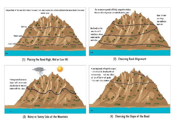
| Location on hillside | Consider placing the road uphill, mid-hill or downhill so as to balance the upstream road catchment and downstream water-use areas. |
| Rain slope | In semiarid areas, place the road on hillsides with more rain to capture more runoff for productive use. |
| Compartmentalization of flood runoff | Use roads to compartmentalize and slow down runoff, especially in areas that are highly susceptible to flooding and deep erosion. |
| Slopes, curves | Provide sufficient curves and breaks on the slope. A steeper road straight up a slope is likely to act as a drainage collector. In some cases, a new road may impose a new drainage pattern on a landscape, with many minor drains discharging into the road. This can happen particularly on hilltops where the drainage pattern is usually not well defined. Care is required to provide an alternation of slopes and curves. |
| Bends | Bends are also exit points for water running along the road surface, and care must be taken to ensure that runoff on road bends is used productively and does not cause undue erosion. |
| Roads in cut | Roads that are at the level of the land or even lower will attract runoff and can become the main drain in hilly sections. These should be avoided. There is a risk of unpaved roads in soft material lowering over time due to erosion and wear and tear of the road surface. When the road is at the level of the land, construction of permanent water bars and rolling dips is recommended to prevent the erosion of the road surface. |
| Groundwater | Consider the effect of roads, either in cut or fill, on shallow groundwater tables and use this to regulate groundwater tables (for instance, creating secure shallow wells upslope from a road in fill) or to plan measures to mitigate the negative effects on groundwater levels (such as additional cross drainage and permeable road embankments). |
Temmink (2015) undertook modeling on a watershed in Ethiopia using an existing 21km road to assess the impact of the road location). The modeling looked at the natural state, the location of the current road at alternative routes (different slopes, different positions on the roads), and various culvert strategies (i.e., different densities of culvert placement). These show the importance of the well-considered selection of road alignment on water harvesting potential, erosion, and road scouring.
- Water harvesting potential is greatly affected by the choice of road alignment. Placing a road lower on the slope and selecting a slope generating higher runoff volumes can increase the amount of water harvested from the road and its culverts by a factor of 7.
- As a general rule, road alignments should be set at toe-slopes ranging less than 40 percent gradient, making it easier to drain (Zeedyk 2006). If roads are developed higher on the slope, they will fail to catch a large part of the runoff; if set too low, drainage will be more difficult and road flooding can occur. In the Northern Hemisphere, roads facing south will dry up more quickly, while those facing north will take more time. However, soils facing north are deeper, thus facilitating road construction and maintenance work.
- Road construction typically increases erosion by at least 10 percent compared to the natural catchment. It is usually higher, i.e., ranging from 12 to 40 percent (Bryan and Schnabel 1994; Luce et al. 2001; Megahan et al. 2001; Wemple 2013).When a catchment is heavily eroded, the road’s additional impact on sedimentation is proportionally less; in fact, roads can help mitigate some of the erosion. Therefore, in relatively pristine watersheds a road’s contribution to the sedimentation process is proportionally higher and may be lower in absolute numbers. However, this effect can be nearly halved with better road location and culvert placement (see Section 3.2). Erosion can be controlled by raising the road embankment, reducing the number of culverts, avoiding the most sensitive and erosion-prone areas, adjusting culvert size, and only using stable or reinforced waterways downstream of culverts and in steep areas that provide an adequate number of bends in the road.
- The scouring of the unpaved road surface is also greatly affected by the choice of road alignment, especially the road’s length and slope. Avoiding long, steep slopes and placing adequate cross drainage can bring down road scouring significantly (see Chapter 11). This contributes to road durability and reduces sediment deposition in the watershed.