Key message
- In coastal lowlands roads serve as flood protection infrastructure and vice versa: this requires cooperation between the responsible organizations in transport, water management and disaster risk reduction to optimize functions and co-benefits and come to joint specifications and better integrated concepts;
- In coastal lowlands roads also have a major impact on water management which is now often manifest in water logging;
- As roads are the main infrastructure in these low lying areas, they can also be used to control water levels for productive use;
- Such measures contribute to the longevity of the lowland road network.
Main techniques
- Several techniques optimize the interface between roads and flood resilience: higher roads or road levees/ flood shelters in flood prone areas, creating flood water storage, using excavation material to make local roads; using low embankment roads in selected areas (Ch 11); evacuation planning, turfing of embankment slopes;
- Several techniques improve the contribution of roads to water management in coastal low lands: road alignment to compartimentalize high and low lands, adequate cross drainage to retain and release water, using gated culverts for water level control, making use of borrow pits for drainage and water storage (Ch 7), using roads for land accreditation.
Objective
This chapter discusses the systematic integration of road development with productive water management and improved flood resilience in low-lying coastal delta areas. It is based on work in Bangladesh but also refers to other countries. The combined planning and management of roads, cross-drainage structures, and flood embankments are powerful strategies to enhance climate resilience, improve flood-disaster risk reduction, increase agricultural production, and ensure the durability and reliability of road infrastructure in coastal areas.
Coastal areas represent 20 percent of the world’s land, but they are home to more than half of the global population and an equal portion of economic activities (World Bank 2008). They offer a rich variety of ecosystems with a range of services, such as storm protection, water purification, nutrient recycling, fish spawning, and recreation (tourism). They also sustain food production (crops, fisheries, and aquaculture).
Due to their location, coastal systems are among the most productive but also one of the most threatened (Dayton et al. 2005). They are at the forefront of climate change with sea level rise, storm surges, floods, and changing rainfall patterns, but there is also a larger picture of changing river regimes, sedimentation patterns in coastal deltas, and land subsidence (World Bank 2008). The latter impacts may be greater than the effects of climate change. Land subsidence in the Ganges Delta, for instance, is estimated at 18 mm/year (Brammer 2014): much more that the expected global sea-level range, projected at 1-2 mm/year (Church et al. 2001).
Roads have a significant influence on the development of coastal areas. Because they are often combined with permanent embankments, they may influence the duration and extent of inundations and the dynamics of flooding in coastal deltas. Roads also fragment the landscape and interrupt the natural flow of water and the movement, sediments, and nutrients important for biological diversity, fertile agriculture, and fisheries (W. Douven, Goichot, and Verheij 2009). Douven et al. (2012) argue that a resilience approach rather than a resistance approach often works better in coastal areas. A resilient approach consists of managing the road infrastructure along with the surrounding landscape, adapting to the broad opportunities of the area rather than reclaiming and protecting as much land as possible, and accepting risks while building in mechanisms to deal with these risks. The resilience strategy aims at minimizing the consequences of floods, while maintaining natural floodplain dynamics as much as possible, whereas the resistance strategy aims at preventing and regulating floods, which has a strong impact on natural floodplain dynamics (Douven et al. 2009)
Opportunities
There is a strong connection among roads, water management, and flood protection in low-lying coastal areas, but this connection isusually not systematically operationalized. This represents both a major missed opportunity and, in several cases, the creation of a substantial problem.
There is considerable scope for an integrated approach in which roads can become instruments for water management and flood resilience in coastal areas. There are three main opportunities: (i) roads contributing to improved agricultural water management; (ii) roads combined with flood embankments; and (iii) roads serving more systematically as temporary flood shelters and evacuation routes. These opportunities are discussed below.
Roads for improved water management within low-lying coastal areas
Roads, bridges, culverts, and gates in low-lying coastal areas strongly influence the flow of water, its distribution, and its levels. The network of internal roads, including small village roads and pathways, divides the areas into compartments, separating relatively higher and lower lands. Road infrastructure may impede drainage and create waterlogging, affecting land use and the soil’s capacity to absorb rain during high rainfall events. Cross-drainage structures (bridges, [gated] culverts, and pipes) are often insufficient, too narrow, and obstruct water flows. Likewise, bridge sills may be too high, impede drainage, and cause waterlogging.
At the same time, although they are now not constructed on these principles, roads can be powerful instruments to better regulate water levels in the fields and contribute to improved agricultural production. If properly fine-tuned, roads in low-lying coastal areas can serve as infrastructure to create areas with relatively low and high water levels and thus allow more varied, multiple-cropping land use patterns. At present, road alignment is not often designed in accordance with the catchment’s hydrology. As mentioned, water-crossing structures may have inadequate dimensions, or may be incorrectly located or absent. Neither are they systematically provided with gates that would provide a major opportunity to actively manage water levels and store and/or release (flood) water between different sections of the low-lying coastal areas. At the same time, erosion and subsidence quickly damage new roads designed without attention to required drainage. In summary, combining road development with water management brings multiple benefits: less waterlogging, less road damage, improved agricultural production, and improved overall livelihoods of rural communities.
Roads combined with flood embankments
There is also a strong link between roads and flood embankments. Many of these embankments are also used as roads: the top of the embankment serves as a subgrade for the road pavement. There are also several examples of roads functioning as embankments of rivers, channels, and canals. There are sometimes mismatches between these transport and flood protection functions. This happens when a paved road is developed on an embankment that has not yet reached its safe and climate-proof level; because of the road, pavement cannot easily be increased. In some instances, the height of the embankment is reduced to create a wider road and improve transport functions. In addition, when a road is developed it tends to compact the body of the embankment: this makes it stronger but also may cause subsidence of the embankment body. This threatens the essential flood protection functions of an embankment. The construction of bridges in the flood embankment may also weaken or strengthen the flood protection functions. The current issues can be turned around by dovetailing road and embankment development, which would make both stronger, and by designing embankments following criteria to accommodate a future road.
Roads more systematically serve as temporary flood shelters and evacuation routes
The third important nexus between roads or embankment roads and flood resilience is that roads act as shelters and as safe havens during times of inundation. Also, after floods recede, roads serve as places where affected people and livestock can temporarily settle and rehabilitate. There is a need to systematically develop these linkages with roads in areas at high risk of inundation providing evacuation routes and safe places for people and livestock.
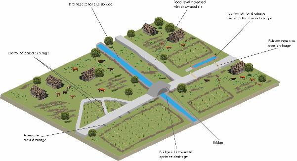
Recommended Best Practices
Best practices (Figure 4.1) are discussed below in terms of these three main opportunities to create more climate resilience, higher agricultural and fishery production, and to better preserve road bodies. This should ideally take place in an overall picture of adequate drainage in low-lying coastal areas with control structures and sufficient capacity for water storage and removal. The functioning of water-related infrastructure can make a major contribution to the agricultural performance and sustainability of all infrastructure in coastal areas, including roads.