The selection of the alignment and slope of roads and the provision of adequate water crossings is critical for the longevity of the road and to minimize the harmful effect of the road on the surrounding environment;
Given the (climate) vulnerability of the medium and high altitude areas it is important to safeguard the road environment with measures that reduce the risk of disturbance whilst also improving the productive value of these areas.
Main techniques
For the development of new mountain roads, the mass balance method should be considered;
Main techniques to manage the water road environment are spring capture, reinforced road water crossings (see also Ch 8 and 9) and bio-engineering.
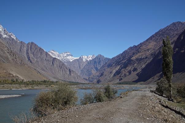
Many high-altitude and middle-altitude areas are at the forefront of climate change. Much of the attention is placed on their medium- and long-term contribution as water towers, safeguarding the future water supply of minor and major rivers that originate from them. Climate change comes in several forms in high mountain regions: higher summer temperatures or more frequent short-duration warm spells; more rainfall but less snow; more wet snow and less dry snow. These changes often unsettle the precarious balance in the mountain regions, causing glacier retreat, more frequent landslides, and the emergence of temporary lakes (see Box 5.1). They also cause mountain areas to become drier in the long run with snow melt becoming a less reliable supplier of moisture. Within this overall pattern of climate change in high- and medium-altitude areas, there is a diversity of trajectories. Lutz et al. (2014) describe various trends in different parts of the Himalayan region, the world’s foremost water tower. Most Himalayan glaciers are losing mass, often on the order of 23 to 56 percent, with significant repercussions for the water security of high-altitude areas. Within the Himalayas, the exception is the Karakoram range where glaciers are stable and are sometimes gaining mass (Bolch et al. 2012). In general, because of glacier melt, water availability will increase until 2050 but decrease between 2050 and 2100 (Immerzeel, Pellicciotti, & Bierkens 2013). Adaptation to seasonal shifts, changed water availability, and extreme events (flooding) are new challenges in the mountain regions.
Road development in mountain regions presents many engineering, logistical, and financial challenges. If done carelessly, the development of roads in these environments can have a heavy negative impact on the surrounding environment and undermine climate resilience. Road development can change runoff patterns and cause areas to further dry out. They can transfigure the face of mountain regions, leaving behind huge erosion scars and accelerating the rate of sedimentation.
This chapter discusses the development of mountain roads and the improvement of the landscape around mountain roads. It argues, as elsewhere, that the development of roads should be seen as an integral part of the development of the landscape in which the road is placed. Yet more than in other chapters, it makes the point that additional measures are required in the mountain landscape surrounding the roads to make the areas more stable and productive and to reduce the exposure of the road to extreme events.
This chapter first discusses the impact of roads on mountain environments (5.2). It then goes on to discuss investments in roads to make them instruments for resilience in their mountain environments (5.3) and the additional measures to be considered in bolstering the mountain road environment (5.4). We argue that road protection and landscape management should be combined to reinforce one another.
Box 5.1. A landslide triggering a new mountain lake
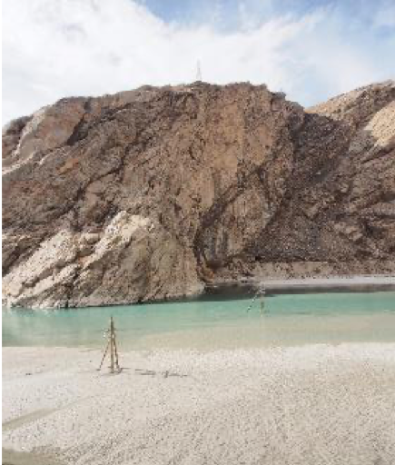
Here is an example of what a landslide can do to connections is Barsem Lake near Khorog in the Pamir Mountains of Tajikistan. Over two days in July 2015, a landslide came down from the small Bersam side valley to the Gunt River, the region’s main river. The landslide came in a series of at least 12 bursts, each time carrying an enormous mass of rocks, sand, and gravel down the valley. It created a solid debris fan 500 m wide and stacked 15 m high in the Gunt River. The landslide took 64 houses along with it. Fortunately, there were no human casualties, because the first landslide burst came in the afternoon, giving people time to move to safer ground.
However, other consequences were dramatic. The landslide blocked the entire Gunt River. This created a kilometers-long lake overnight, covering land along the river and inundating the main road up to the border. It also submerged power lines from the Pamir-1 hydropower plant. This isolated the area and disrupted all logistical supplies. No power was provided to Khorog. Transportation in Tajikistan to and from China came to a halt. Disaster response was swift. Power connections were restored within days, using an entire new route of pylons. The emergency road higher up the mountain was constructed in 42 days, engaging all equipment that could be mobilized.
After one year of considerable effort, local engineers finally managed to slightly unblock the river with the help of dynamite and excavators. Only a narrow through-fare could be made in the debris fan, taking some of the pressure off the newly formed Barsam Lake. The larger part of the river is still filled with the landslide material that over time is becoming more compact. There are plans to remove all material, but looking at the blockage one is reminded that the human endeavor to resolve such problems is tiny in contrast to our capacity to create the problems in the first place.
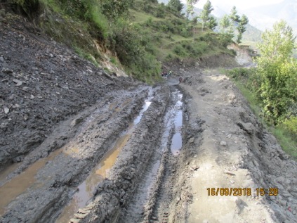
It is unavoidable that the development of a road changes the environment of mountain areas: the hydrology, microclimate, and sedimentation patterns. The changes in hydrology concern several dimensions. First, the development of a road changes surface runoff patterns. Rather than flowing down a smooth gradient, the runoff is interrupted once or several times while descending from the newly cut hillside. The flow velocity is reduced as the runoff touches the road surface and erosive force is released. As the runoff touches the road surface it may concentrate and accumulate along the road surface, effectively changing the natural drainage pattern. Secondly, in a similar fashion the subsurface flows are interrupted in road construction (see figure 5.1, also chapter 3). The degree to which water travels in the upper soil layers and geological formations differs from place to place and from road section to road section. Roads disrupt these shallow moisture flows and, in many areas, cause new springs and seeps to emerge.
A third effect on hydrology is that with the opening of the hilly terrain the road cut also opens up fresh mountainsides and increases the air-surface exposure of the hill slope (figure 5.1). This will dry out the hill slopes, particularly when the slopes are freshly cut. There is, moreover, a gully effect with soil moisture moving towards the road cut from where it constantly evaporates. Unless the side slope is covered again with vegetation, it may lead to a ‘bleeding’ of the subsurface moisture, drying up hillsides. Fourth, the construction of roads will also increase the so-called hydrological connectivity of the watershed. Hydrologic connectivity describes the degree to which elements in a landscape are interconnected. The higher the connectivity the faster the rainfall run off, causing peak flows in the rivers to emerge early and be more pronounced (Meng, Wu, & Allan, 2013) – see also Chapter 3. Road development has generally accelerated runoff, making new connections and concentrating flows in a smaller number of drainage lines.
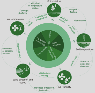
Furthermore, the opening of the roads in steep mountain terrain has a large bearing on the microclimate (see figure 5.2) of roadside areas, which can be observed, for instance, when forest areas are traversed. The impact on the microclimate comes from the changed hydrology and from the greater exposure of the mountain slopes to sun and wind and reduced tree canopy once roads ‘open up’ the roadside environment. The general effect will be for the area surrounding the mountain road to dry. Such drier road environments and lowered soil moisture effect soil temperatures (more heat exposure) and microbiology. When soils are less moist there is less microbial action in the soil which will, for instance, reduce the capacity to fix nitrogen, with repercussions for vegetative growth. We also see gradual drying, the increase in day temperature, and a lowering of night temperature. This may also affect local rainfall patterns and the occurrence of dew, which is an important source of moisture for vegetation. To rebalance this, measures should be taken to retain moisture and regreen the area.
Finally, roads also trigger sedimentation in mountain environments. The cut section of the road and road surfaces are vulnerable to erosion. Much erosion occurs during road construction, further aggravated when slopes are unstable. Erosion control should be part of the methods of road construction and of additional measures taken. This is, of course, at its most spectacular in the shape of landslides and mudflows that may be triggered by the development of roads, either because they destabilize hillsides, cross unstable mountain sections, or cause seepage that triggers dramatic landfalls. The topic of roads and landslides is covered in a broad range of literature and is not discussed further in these Guidelines.
Figure 5.2: Interlinked components of micro-climate
When making a mountain road that contributes to resilience and can withstand shocks and stresses, there are a number of considerations:
Choosing the road alignment and design carefully;
Choosing the appropriate construction method;
Including protected road water crossings – such as tilted causeways, reinforced causeways (drifts) at ephemeral stream crossings, dissipation blocks, check dams and downstream protection infiltration road-side bunds;
Managing roadside springs and seeps.
5.3.1 Choosing the road alignment and design carefully
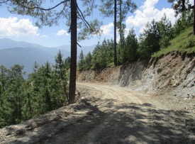
The choice for the road alignment and design goes a long way to ensuring the sustainability of the road and its contribution to the resilience of the landscape. A first important consideration in selecting a road alignment is that it should not disturb runoff patterns. With steep slopes in mountain regions, the high speed of runoff can create havoc for sometimes unstable slopes. There are a number of considerations. First is to observe reasonable longitudinal slopes. In the Nepal Rural Road Standards, for instance, 7 percent is taken as the ruling gradient (for a maximum distance of 300 m). The recommended limiting longitudinal gradient in mountain roads is 10 percent, with a maximum slope of 12 percent as an exception. Beyond this, the road will act as a drain, collecting water during rainfall events and causing extensive rutting to the road surface. Such steep, rutted, and often slippery roads are dangerous for vehicles, and are sometimes impossible to pass. They also alter the drainage pattern of the mountain slopes. Choosing gentler slopes has cost implications, as the length of the road will increase and there will be more bends. However, these costs are recovered through road functionality and reduced damage to the surrounding landscape. A second point is road drainage. The Green Roads criteria developed in Nepal are recommended to have free-draining, downward sloping road crowns to gently spread the runoff that gathers on the road. Good water exits at hairpin bends are required so that water does not remain on the road surface in these sections and careen downstream where it will accumulate and cause damage. A final point in selecting a road alignment and design is to incorporate road water crossings with an adequate number of causeways (or drifts) at stream intersections and other measures to control for stream crossing and spring management/
A second consideration in selecting a road alignment is to keep a safe distance from existing streams and rivers and to prevent the road from getting inundated or damaged by floods in such rivers and streams. The road layout should be aligned with the current and predicted hydrological situation. Roads should be at a safe elevation and distance from mountain rivers. An analysis of current hydrological data and future scenarios can inform this decision.
5.3.2 Choosing appropriate construction methods
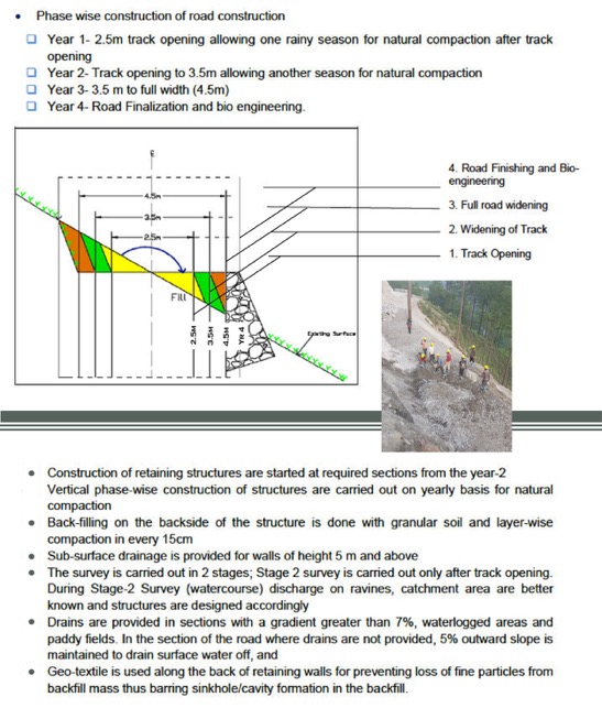
Several methods can be chosen to develop mountain roads. A method that is worth considering is the cut and fill, applied in Nepal in several programs. One central element is ‘mass balancing’, i.e avoiding wastage of mountain material. In mass-balancing, the spoil that becomes available with the cutting of the road is used to make the downslope toe of the road. This has two main advantages. The first is that it reduces the amount of unused spoil significantly, because the spoil is reused in making the downslope toe. The second advantage that there is less cutting of the mountain slope, because the new road width is created both by cutting the mountain slope and adding the downslope toe. Compared to other methods, the height of the road cut is decreased and with this the risk of erosion, instability, and drying out of the hillside. The roads are ideally developed over a period of 3 to 4 years, allowing the road to settle and consolidate before it is further widened. The preferred method of construction is labour based, creating employment and skills (see Chapter 13) but also allowing careful handling of the construction process. Box 5.2 describes the green road cut and fill method 1.
Box 5.2: Green road cut and fill method explained
Box 5.2: Green road cut and fill method explained
Instead of the labour-based approach described above, machine-based approaches are used in road construction to save cost and time. In this machine based approach, a ‘cut and throw’ method is used, whereby the upper hill slope is excavated and the excavation material, rather than being used for the down slope toe, is dumped downhill. A modified hybrid method may be used, whereby roads are opened up by (trained) excavator operators. Remedial work may be undertaken by labour groups, such as the development of slope protections, breast walls, and general road clearance. There is, however, a marked difference between the labour based cut and fill approach and the hybrid mechanical approach, captured in table 5.1. In general, the faster turnaround time and the lower the costs of the hybrid mechanical method comes at the cost of more environmental damage, less reuse of the spoil, less attention to springs, and a loss in labour opportunities. For Roads for Water, the labour-based approach is preferable. In the mechanized approach, the additional measures described below are even more urgent.
Table 5.1: Labour based and mechanical approach to mountain road construction compared
Parameters
Labour intensive cut and fill method
Mechanised cut and throw method
Design approach
Cut and fill
Cut and throw
Slope exposure
Shorter side slopes
Higher side slopes (up to 40% higher)
Loss of land
Estimated savings of 6,320 m2 per km over conventional cut and throw methods 2
Much land – including productive land – lost
Slope stability
More stable
Disturbance because of mechanical action – needs remedial action
Road surface stability
Natural stabilization and compaction of road surface related to phased approach
Entire width of the road opened up at once creating less stability
When a mountain road is opened up, many new road water crossings are created over regular streams that are interrupted or torrents that only flow during the rainy season and now descend on the road body. Unless measures are taken, these interrupted streams and torrents will damage the road surface by their erosive force and create extensive wet road sections that are easily damaged by traffic impact. Erosion may easily extend to the land alongside the road. To reduce the damage from these water crossings, several techniques are proposed: causeways, dissipation blocks, check dams, infiltrating bunds, and down-road protection. Many of these measures can make use of the spoil and rubble that becomes available if a road is constructed.
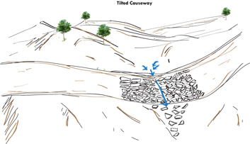
Tilted causeways. Roads are traversed by several mountain streams. At these places, causeways should be made of flat stones. Like the entire road, causeways are tilted at a slight angle (maximum 4 to 5 degrees[5]) towards the downhill side to facilitate the drainage of the water from the stream. This is a good practice, as it ensures the use of local material and provides structures that are easy to maintain. To improve and guide the removal of water, a depression can be made in the middle of the causeway. This depression is to be modest. If the causeway has a width of 25 m, the lowered section should be 25 cm to 50 cm. The depression should be at an angle of a maximum of 5 degrees so it does not interfere with the road trafficability. Where the road water exits the tilted causeway, it may be useful to armour the downstream part of the stream. Using a tilted causeway on sloped terrain has several benefits:
It forces the stream and torrent flows towards the middle of the causeway and continues their flow in the existing drainage path, avoiding uncontrolled erosion of down road hill slopes.
It reduces the chance of side-spills from the causeway during high discharges that may damage the road body.
Figure 5.3: Tilted causeways
Reinforced causeways (drifts) at ephemeral stream crossings. Where roads cross the dry bed of ephemeral streams, reinforced causeways or drifts may be used. Besides their functions as traffic conduits, they help stabilize the unstable gravelly stream beds in mountain environments. They may also help to retain water in the sand and gravel of the river bed. Chapter 8 describes the application of such non-vented drifts in semiarid areas. For this, the drift may be reinforced beyond normal specifications so as to withstand the pressure of the torrential flows and the impact of rolling boulders. The drift should not be equipped with culverts. Besides the body of the drift itself, the drift consists of the approach road, the upstream protection of the stream, and the downstream apron. Because of the heavy natural armouring of mountain streams, they may not need a downstream apron.
Figure 5.4 Dissipation block placement on the road
Dissipation blocks. Where a minor stream descends on the road, the use of dissipation blocks is recommended. This may be created by stacking up stones and rocks that become available when a mountain road is opened. These stockpiled stone blocks dissipate the force of streams and torrents if they are placed where those hit the road. This measure comes at no extra cost, as the stone blocks are stockpiled for use in future repairs yet are often placed off-stream. The blocks are best placed 30 cm to 40 cm away from the side-slope, and flat stones may be placed between the torrent coming from the hill slope and the dissipation block in order to break the velocity impact of the descending water. The stockpiled stones will further ‘baffle’ the force of the mountain stream. A small depressed section may be created in the road body, like a mini-causeway, to guide the stream water across the road.
Check dams and downstream protection. In the accented terrain, most streams will flow at high velocity. The development of a road section creates chutes that can do considerable damage to the road surface and side slopes. Making check dams in the upstream section of these road streams reduces the velocity of water crossing the road. Again, spare stone material from the road construction may be used to build up small check dams upstream. The excess material may also be used to armour the down road part of the stream by placing some stones there. This will prevent damage from erosion to the landscape and avoid upward gully development that could affect the road body. The general criteria for check dams are: 5
Spacing between check dams = height * 1.2/ slope of stream in decimals
Side key of check dams 0.7 m to 1 m each side
Bottom key and foundation 0.5 m deep
Height of check dams 1 m (maximum excluding foundation)
Stone face vertical to horizontal ratio 1:3 to 1:5
Spillway (preferably in trapezoidal shape) width 0.75 m to 1 m; depth./ freeboard 0.25 m
Using rock rubble for apron immediately downstream: length 1 m and width 0.5 m
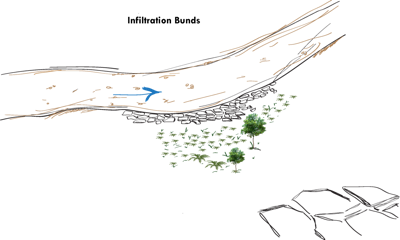
Infiltrating road-side bunds. During the monsoon, fine material from the unpaved roads is washed into the adjoining agricultural land causing loss or damage to crops, often forcing farmers to replant. A good practice in mountain roads is to use an outward sloping road crown to drain water evenly from the road to the adjacent land. The slopes preferably have a maximum inclination of 5 percent to prevent runoff from traversing the road surface. Even so, a certain amount of concentrated flow along road sections is unavoidable, in particular in sloping road sections. To prevent this, infiltrating bunds in downslope road reserves can be used in areas where road water is expected to wash into agricultural land, comparable to those described in section 9.3.3.
Infiltration bunds can be made of road spoils, particularly uniform flat stones. The flat stones are placed in a dense mosaic in the road shoulder on the downstream side of the road. The width of the infiltrating bunds may be equal to the width of the road shoulder. The stones are placed in a pattern whereby larger stones (diameter of 20 cm to 25 cm) are placed close to the road surface, followed by a row of smaller stones (diameter 10 cm to 15 cm). The open space between the stones is preferably equal to 25 percent of the surface.
Figure 5.5: Infiltrating bunds
5.3.4 Managing roadside mountain springs and seeps
In mountain areas, the development of roads—either though the removal of unconsolidated material or the cutting of rock formations—will affect the occurrence of seeps and springs. Different from a spring, a seep does not have a clear orifice and water exits over the entire water bearing strata. The management of such springs and seeps is important: in many mountain regions they are the main source of domestic water supply and small-scale irrigation. Table 5.2 shows the effect of the opening of a new road alignment on different spring types. The development of roads may distort existing springs but may also create new ones. Given the importance of springs for domestic water supply or agricultural use, the management of mountain springs in road development should be an integral part of road construction. The springs and seeps are also main sources of road damage, either by affecting the road surface directly or by creating (minor) depressions in the roads that grow during the monsoon and cause uncontrolled and erosive runoff from road bodies.
Figure 5.6 Road opening a seep that next damages the road surface (Mugu, Nepal)
There are several types of springs. Geomorphology, rock type, and tectonic history determine the type of spring that occurs. Two broad categories are springs with concentrated discharge through one or more clear orifices, and springs with more diffuse discharge. The different springs and the effect that road development will have on these springs is given below.
Table 5.2: Effect of road development on different types of springs
Spring Type
Description
Effect of road development
Springs with concentrated discharge (through one or more orifices)
Fracture springs
Faults, fractures, and cleavage in semi-permeable and permeable formations connected with a water source (seepage, flow, shallow, or deep aquifer)
Road development may expose the spring; rock cutting may change the location of the orifices – either blocking old or creating new ones
Contact spring
Permeable layer overlays an impermeable layer, forcing water to come out – often in a line of springs
Road may distort the outflow of the spring, causing orifices to be blocked or new ones to be created – highly dependent on geological faulting
Fault spring
Due to geotectonic movement, a permeable layer is moved on top of an impermeable layer
Road may distort the outflow of the spring, causing orifices to be blocked or new ones to be created – highly dependent on geological faulting
Depression springs
The groundwater table reaches the surface in topographical low
Road may create new depression springs where the roads are made in cut, or dry existing springs by lowering the groundwater table
Karst springs
Relatively large flow from large openings – typically in karst areas where water erodes the calcium formation
Roads may expose new springs and expose new cavities
Springs with diffuse discharge
Seep
Diffuse direct discharge of water, usually from soils or unconsolidated sediments (sand or gravel)
Road development may create many seeps, especially where roads are developed in areas with deep soil profiles
Secondary springs
Water issued from a primary spring that is typically covered by debris or rock fall
Road development may expose springs or change the outlet, in particular where unconsolidated material is removed
Managing the springs along mountain roads is important for safeguarding road quality and ensuring water supply for domestic and agricultural use. It is recommended that before the road is built, the geology must be understood and the areas where springs occur or are likely to occur should be mapped. When roads are being constructed, they effect the location of the spring if not handled carefully. The use of bulldozers or excavators in areas of potential springs should be avoided; manual labour should be used to excavate the road in such sections.
Once the road is developed, the presence of springs and seeps will be evident. A choice has to be made whether the spring or seep will be used or not. In areas with a low population density, springs may not be used, but they should still be managed to prevent discharge from damaging the road body. The following table suggests methods for managing different types of springs in different circumstances
Table 5.3: Recommended practices for spring management along roads
Spring Type
Description
Spring management
Spring with concentrated discharge
Not used
Retaining wall with weep holes or with longitudinal drain to collect excess water and traverse drains (French mattresses) underneath the road
Used for agriculture
Retaining wall with longitudinal drain to collect excess water and traverse drains (French mattresses) underneath the road
Used for domestic water supply
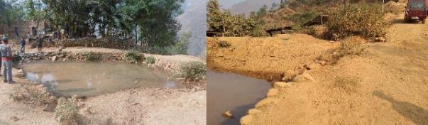
Spring box (captage) and conveyance to benefit community, or tap fitted on protected spring
Used for domestic water supply and storage
Spring box (captage) and conveyance to benefit community. Include possibility of spring closure (tap) to store water inside the mountain aquifer (especially in karst areas)
Spring/ seep with diffuse discharge
Not used
Develop road drainage in up-road section to collect seepage and convey to safe place
Used for agriculture
Use gravel section in road to convey water to agricultural land
By controlling the outflow of the springs, water can be better retained in the area. Equipping the orifice of a spring with a gated outlet and even a tap makes it possible, in some cases (especially karst springs or fracture springs), to store spring water in the mountain aquifer. The outflow is regulated and retained in a controlled spring, creating storage in the mountain aquifer and prolonging the time during which water is available.
Bio-engineering
Bio-engineering concerns a range of vegetative measures to stabilize slopes along mountain roads. One relatively widespread application is the use of vetiver grass. Due to its deep strong roots and high survival rate vetiver rows have been applied widely on steep erosion-prone slopes. In steep areas as in Nepal often a combination of vegetative measures with structural measures are used along road sections. Preferably native plants are used that are known to adopt well to the harsh settings and that have the positive mechanical and hydrological characteristics to strengthen the critical slope segments. Plant shoots are preferably planted when the live cuttings are without leaves still. Vegetative measures are often combined with a (gabion) stone toe that stabilizes the slope with plants placed on the upper sections. To further protect and reinforce the slopes additional measures are used a such as brushwood matrasses, fascine bundles, timber crib walls or rip rap in selected sections (see also Annex 1).
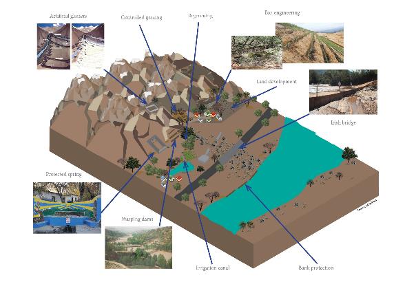
Mountain areas are highly challenging for road connections at any time. To create resilience in these areas, it is necessary to work on both the roads (section 5.3) and the demanding environment in which they are located. Safeguarding the road environment will protect the road but will also create a large productive asset. The purpose is to create a more stable and productive environment, making better use of the opportunities that exist in high- and middle-altitude areas. The recommended measures serve to better retain moisture and to build up, enhance, and protect land. (See figure 5.7. In this section) several measures are discussed:
Land-use planning;
Water and snow storage measures;
Artificial glaciers;
Land development;
Water retention on mountain slopes;
Reusing soil;
Controlled grazing; and
Re-greening and roadside tree planting.
Figure 5.7. Integrated road landscape management measures to be considered in mountain areas
Land-use planning
Mountain areas are characterized by steep slopes and limited land for cultivation and habitation. At the same time, many areas are exposed to the risk of mudflows, rock fall, and flooding. Over time, people have encroached on these high-risk areas and, for instance, have built houses on scree slopes. Stronger land-use plans and regulations are required to prevent this and relocate those most at peril. At the same time, land-use planning for high-altitude areas can be used to introduce and plan several other measures in road development, create storage and regreening, and designate areas for pasture development.
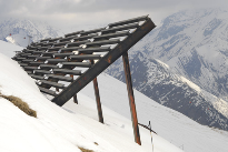
Water and snow retention and storage
Over time, the water-storage capacity of high-altitude glaciers has been disappearing. This will need to be compensated by alternative storage methods and better retention of water and snow, which will also reduce the risk of disruptive floods. Several measures will slow snow retention, help keep the snow on the slope, and prevent avalanches in critical areas.
More water storage may be created, as in other Roads for Water programs, with special farm ponds or converted borrow pits or by using road bodies to create reservoirs. (See Figure 5.8.) Check dams and irrigation diversion channels can also be used to decrease the amount of water streaming down and delaying peak floods. Another advantage is that check dams provide an additional source of water that can be used in summer when seasonal streams and springs dry up. However, these infrastructure projects should be carefully planned so as not to increase the risk of floods and mudslides for populations downstream. Other measures, such as reforested areas and livestock enclosures, will also increase water retention in the soil.
Snow shed in alpine environmentFarm ponds in high-altitude Nepal
Figure 5.8 Water and snow retention measures for high altitude areas
Artificial glaciers
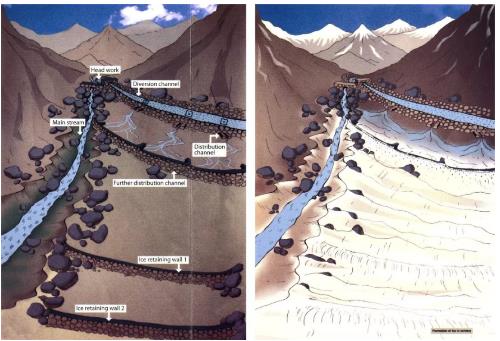
The development of artificial glaciers is an ingenious technique first developed by local engineers in Ladakh (North India). The principle consists of diverting water from glacial streams through canals and pipes (up to 4 km long) to shaded, colder, and flatter areas, where the difference in temperature and lower velocity of water are sufficient to make the water freeze again. When the meltwater reaches the artificial glacier site, it is spread and contained with retaining walls of stones or concrete built in series. The artificial glaciers may be up to 2 km in length and 2.5 m in depth. The water is stored there during the entire winter and melts in spring when temperatures and sun radiation increase. Artificial glaciers have several advantages for agriculture and road infrastructure:
They make water available before higher glaciers start melting, enabling farmers to begin cultivating earlier in the season;
They reduce the amount of meltwater lost to the high-altitude area; and
They reduce peak floods, erosion, and damage to infrastructure.
Figure 5.9 Technique for creating artificial glaciers in mountain areas. Source: Fondation Ensemble
Land development with meltwater
Especially in young mountain areas, intense sedimentation may lead, for instance, to a reduction in downstream reservoir capacity. However, sedimentation is not necessarily a hazard: it can be an asset as well. It helps build or renew soils, creating new land and plugging gullies and depressions. “Warping” techniques can be used to trap sediment for beneficial use. Warping entails building up land with moisture-rich soil along rivers and streams. It can be done by letting turbid water flood onto agricultural land so that its suspended sediments form a layer, before letting the water flow away. Roads can be also be used to guide such meltwater. In this way, poor soils are enriched with fertile fine silt (or warp) or by trapping sediment behind warping dams built on gullies or steep valleys to intercept sediments and thereby create new land terraces.
Box 5.3. Warping dams
Warping dams are typically up to 5 m high, but they can be lower as well. The development of a warping dam consists of two stages: the land development stage and the consolidation and management stage. The land development stage takes several years (on average three to five years, but sometimes more than ten years). By then, warping dams have collected enough sediment for farming to begin. After this consolidation starts, stabilization is necessary when the dams are completely filled with sediment, in particular the creation of controlled water overflow structures. This can be done by changing the existing spillways into a circular shape, redesigning the top of the shaft as a spillway, constructing a side spillway, or designing an earth dam as an overflow dam (Steenbergen, F. van et al., 2011).
Improved moisture retention on hill slopes
The changes that come with the road construction are described in Section 5.2: changed hydrology, opened up hill slopes, more exposure to sunlight and wind). These changes add up to a severe effect on the microclimate that could affect the forest stands or the quality of the pasture. The impact on the microclimate will be less water retention, resulting in a loss of moisture, an increase in temperature, and more desiccating effects.
To counterbalance this effect, the capacity of the road affected area to retain moisture should be increased. This will also reduce the risk of erosion and degradation of forest hill slopes. This will contribute to the regreening of the area, including the compensation of those trees removed during road construction. The presence of large quantities of spoils (rocks and boulders) from road construction again presents the material for these measures. For steep mountain slopes, the use of eyebrow terraces/half-moons and stone strips/ rock bunds is recommended. Eyebrows/half-moons are small, semi-circular, and stone-faced structures that open in the direction of the run-off (figure 5.10). They can be built on steep slopes, usually with a maximum preferred slope of 50 percent, yet steeper gradients are possible, especially when rainfall is not torrential, as in the project area. On a slope, the steepest sections should be avoided, and the eyebrows may be reconstructed in the gentler sections. The suggested dimension and spacing of eyebrow terraces is given in Annex 8.
Figure 5.10: Eyebrow terraces on mildly sloping land (Ethiopia)
The eyebrow terrace can be complemented by stone strips or rock bunds, particularly on slopes that are relatively even and not too steep (<50 degrees). These stone strips will slow runoff, intercept sediment, and build up soil layers. They will stretch over the width of the slopes, allowing water to filter through as they are permeable.
Make better use of excavated soil
Soils are removed when roads are constructed. The construction of 3.5 m-wide section of road for 1 km with a soil depth of 30 cm would yield 1,050 m3 of soil. This is a valuable asset in land development and in re-greening hillsides. These hillsides are often deforested and stripped of vegetation during the road building process. By setting aside this soil in combination with eyebrow terraces and stone strips, the replanting of trees on hill slopes can be accelerated, and the watershed can be protected.
Controlled grazing
Uncontrolled grazing can be a major cause of land degradation in medium- and high-altitude areas. To reverse this trend, area enclosures, better pasture management, and in some cases reduced livestock herds are recommended to restore pastures.
In controlled grazing, the areas are well defined, and their use, closure, and resting are regulated. “Resting” is generally proposed to restore perennial grasslands. This may result in an initial burst of growth in vegetation that was being overgrazed and can now grow freely. Properly grazed grasslands act like sponges, storing humus and carbon. The roots of grasses perforate the soil and open it up, increasing porosity and infiltration capacity. The trampling of the sealed soil surface, or soil crust, by animals helps this process. The increase in porosity and infiltration capacity allows water to soak in where it can be used by plants, or eventually trickle down to feed springs, rivers, and boreholes or wells, thus increasing the residence time of the rainfall in the catchment. Controlled grazing also decreases risks of floods and siltation downstream and the resulting damage to road infrastructure.
Grazing areas may be further enhanced by flood water or melt water spreading. When water is flowing in the mountain streams, it may be diverted to grazing areas if these are short of moisture. This will also prevent the risks of floods, as water is spread over a large area. Care should be taken to avoid interference with existing downstream water uses.
Re-greening
In several mountain areas, the demand for fuel wood and timber has had a severe impact on stands of trees and shrubs. Re-greening will stabilize slopes, help retain water, and even change the microclimate by achieving shorter precipitation cycles. Re-greening involves a series of measures: land use planning and controlled grazing are often prerequisites for successful revegetation. Regreening campaigns may incentivize mountain communities or forest enterprises to plant and safeguard new tree stands. Alternative arrangements can be powerful too, such as farmer-managed natural revegetation, whereby natural tree sprouts are protected and nourished; farmer-owned timber or fuel wood plantations; and agro-forestry farms or roadside tree plantings (see Chapter 11).